Kitchin was born in Southwark in 1719, and apprenticed to Emanuel Bowen in 1732. In 1739 he marries his master's daughter, Sarah Bowen, and after her death he married Jane Burroughs in 1762. He set up his own works in Clerkenwell, and then in Holborn Hill by 1755. He later retired to St Albans, where he died in 1784 (relatively prosperous, unlike Emanuel and Thomas Bowen).
Kitchin was an excellent map engraver, with clear lines and excellent spacing of the details on the maps, giving rise to extremely readable maps. He shared with the Bowens a standard compass rose symbol on all (?) of his maps; the existence of this symbol on a map will strongly indicate that it is a Kitchin and/or Bowens production.
He produced alone or with others many individual county maps and county atlases, as well of overseas locations such as North America and the Caribbean. His county maps are based on the (surveyed) map of Warburton - originally published in 1724, so not particularly up to date, although probably little was changing across Essex at the scales he created maps. The maps of Essex he created are listed below, together with examples:
| Links to examples | Notes |
|---|---|
1748 The London Magazine was published monthly from 1732 to 1783, and contained county maps at random dates between 1747 and 1763; Essex was published in the August 1748 issue. The maps were later issued as separate sheets, at 3d each, but these seem to have not sold well, as none have been seen. Essex is not included in the Dublin re-printings of the London Magazine. 216mm x 267mm. Scale correct at 9 miles = 39mm, or 5.9 miles/inch, ie 1:375,000. These map plates were re-used by Hogg in 1787, in his Historical Descriptions of New and Elegant Picturesque Views of The Antiquities of England & Wales. This was one of several part works from Alexander Hogg (Boswell being a pseudonym used on the frontispiece). The full work was published under this and other titles 1787-95. |
|
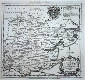
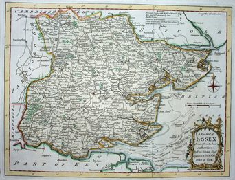
The Universal Magazine was published monthly from 1747 until 1799, published by John Hinton until his death in 1781. County maps were published from June 1747 until September 1766, and then a completely different set from 1791 to 1798. Essex was published in January 1750, drawn by Thomas Kitchin (who was officially working for the London Magazine by then). 178mm x 191mm. Scale correct at 10mls = 30.5mm, or 8.2 miles/inch, ie 1:515,000. |
|
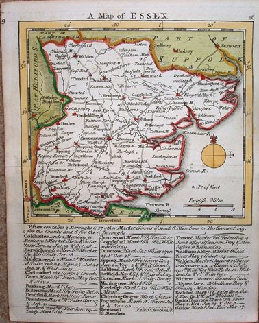
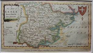
Issued initially as a weekly part work from November 1748 onwards, the Essex map was first issued in late January 1748/49. The complete Small English Atlas was published in 1751, with plate numbers added to the maps. Below the map are listed notes on towns, representatiion and the weekly market days plus dates of annual fairs for 28 towns, starting with the Parliamentary Boroughs. 119mm x 135 mm (map only). Displayed scale of 12 miles = 29mm, or 10.5 miles/inch; scale actual = 11.8 miles/inch, or 1:745,000. There was a new edition in 1775, with some minor revisions to the map (eg a few roads have been added). The text below the maps has been erased and replaced by a new listing of towns in alphabetical order. Against each town is listed their market day and date of annual fairs. The maps will re-appear in Kitchin's An English Atlas in 1776 et seq. |
|
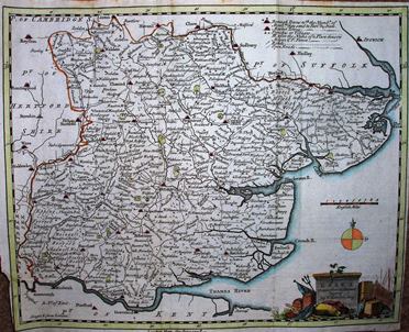
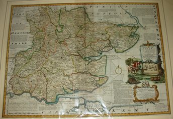
The Large English Atlas was led by Emanuel Bowen, with Kitchin as one of his workers on the individual map (Essex being created in 1749), and then setting up on his own account before the Atlas was published. Displayed scale of 15mls = 137.5mm, or 2.8 miles/inch; actual scale = 2.5 miles/inch, or 1:158,000. |
|
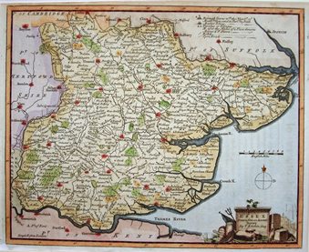
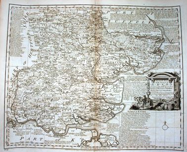
R & J Dodsley published his 2 volume topographical work, England Illustrated, in 1764 (Essex is in volume 1), mostly using text from Camden, Speed & others, plus Kitchin maps based on the Large English Atlas. The whole work was then re-issued as a part work from 1764 to 1765. This publication seems not to have been a great success, and was not issued again, but the maps appeared in Kitchin's English Atlas in 1765 (without texts). 194mm x 255mm. Displayed scale of 12 miles = 40.4mm, or 7.5 miles/inch; actual scale = 6.8 miles/inch, or 1:435,000. |
|
The Royal English Atlas was published in 1764, derived from the Large English Atlas, again led by Emanuel Bowen. There are some suggestions that this was also published by Kitchin as the English Atlas in 1765 (although this may be a mis-association with the atlas of that name which was published later, being a reprint of the Royal English Atlas - see Bowen). Scale correct at 12 miles = 90mm, or 3.4 miles/inch, ie 1:215,000. |
|
|
... |
1769 Kitchin's Pocket Atlas, based on his England Illustrated (above); re-appears in 1778 as Bowles Pocket Atlas. |
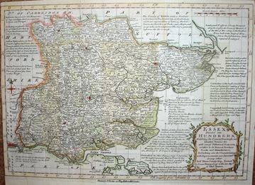
The Bowens (E & T) had published Atlas Anglicanus in 1767, a reduced version of the earlier Royal English Atlas and uses abbreviated versions of those notes around the map. (The latter Atlas was itself a reduced verion of the Large English Atlas). This was first published as a part work from 1767 to 1768, and then as an atlas in 1768. This is the 2nd edition of 1777, as does not have an "8" in the top right corner, and has Thomas Kitchin's name across the bottom. The maps were used again by Bowles in 1785. Displayed scale of 14 miles = 53mm, or 6.7 miles/inch; actual scale = 5.9 miles/inch, or 1:370,000. |
|
George Augustus Walpole (or Walpoole) (& others) was a fictional name invented by Alexander Hogg for his New British Traveller, to make it appear many people were involved in his many part work publications. This one was issued in 60 weekly parts, in 1783/84. The maps were re-engravings, generally to a poor standard, of Kitchin's England Illustrated maps of 1764. The text across the base of the map indicates this is a later printing, but not when exactly (sometime 1784-1793). Displayed scale of 20 miles = 42mm, or 12.1 miles/inch; actual scale = 10.8 miles/inch, ie 1:685,000. |
Return to the Map publishers main page.